The oldest landscapes on Earth you can visit today

A backpacker gazes over layered mountain ridges rising above morning cloud cover. These highlands represent some of Earth’s most enduring continental crust, landscapes shaped by billions of years of tectonic stability and erosion.
Walking on deep time
Imagine standing on rock that formed before trees, before animals, before oxygen filled the sky. Imagine placing your palm against stone that cooled while the young Earth still smoldered from its own making. The mind resists such scale. It prefers centuries, not billions of years. Yet there are places where deep time does not hide underground or behind laboratory glass. It rises into light.
Some of the oldest rocks on Earth are not sealed inside research vaults. They are landscapes you can walk across. They are mountains you can climb, river valleys you can trace with your boots, desert plateaus that hold the memory of an atmosphere without breath. These ancient landscapes you can visit are fragments of the Archean world — survivors of planetary violence, tectonic recycling, erosion, and unimaginable heat.
In this journey, we will travel across four extraordinary regions where 3 billion year old rocks and older still remain exposed to the sky: the Guiana Highlands of South America; the Barberton Greenstone Belt of southern Africa; the Pilbara Craton of Western Australia; the Isua Greenstone Belt; and the Acasta Gneiss Complex of northern Canada. Together, they form a scattered archipelago of Archean cratons, Earth’s structural bones, still holding the continents upright.
To stand on them is to stand near the beginning.
What makes a landscape “one of the oldest”?
When we call a place one of the oldest landscapes on Earth, we must be precise. There is a difference between ancient rock and ancient topography. Mountains rise and fall. Valleys open and close. Erosion reshapes everything. A summit may look eternal and yet be geologically young.
What endures far longer is crust — particularly continental crust. The oldest rocks on Earth belong mostly to stable cores known as cratons. A craton is a thick, buoyant block of continental lithosphere that has survived the churn of plate tectonics for billions of years. Beneath it lies a deep “root” extending into the mantle, giving it remarkable stability.
During the Archean Eon (4.0 to 2.5 billion years ago), Earth’s crust was hotter, thinner, and far more volatile. Much of it was recycled back into the mantle through subduction. Oceanic crust, even today, rarely survives more than 200 million years. Continental crust, however, can endure — if it becomes thick and chemically buoyant enough.
The ancient landscapes we can visit today sit atop such survivors. Their surfaces may have changed, but their foundations belong to a world where continents were only beginning to form and life was microscopic, tentative, experimental.
They are not simply old mountains. They are preserved chapters from Earth’s first volumes.
1️⃣ The Guiana Highlands — lost worlds above the clouds
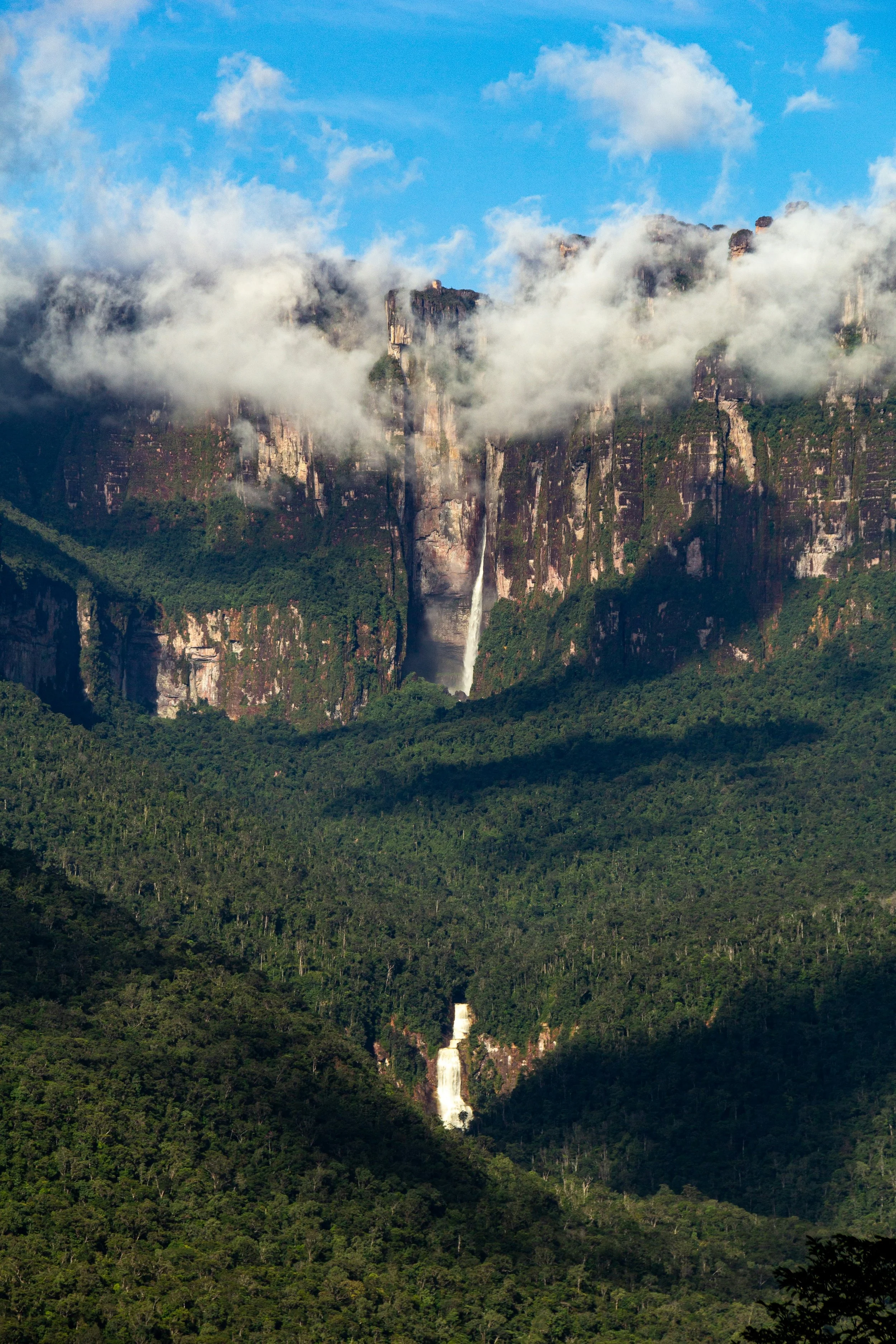
Angel Falls plunges from a towering tepui in Venezuela’s Guiana Highlands, part of the ancient Guiana Shield, one of the oldest continental crust formations on Earth. These dramatic sandstone mesetas rise above the Amazon basin, preserving billion-year-old geological history in one of the world’s most extraordinary ancient landscapes you can visit.
In northern South America, between the Amazon and the Orinoco, rises a vast geological memory: the Guiana Highlands. According to the Britannica Editors (2024), this region spans southern Venezuela, Guyana, Suriname, French Guiana, northern Brazil, and southeastern Colombia — a broad expanse of plateaus and low mountains geologically allied to the Brazilian Highlands yet separated by the Amazon basin.
Beneath the forest lies the Guiana Shield, a geological formation between 1.7 and 2.5 billion years old, as described by The Amazon Conservation Team (n.d.). It covers roughly 270 million hectares and represents around 40% of the Amazon biome. This is ancient continental crust — part of Earth’s early architecture.
The landscape unfolds in tiers: low rolling hills under 300 meters; uplands rising between 600 and 900 meters; and then, abruptly, sandstone mesetas thrusting skyward. The most iconic are the tepuis — flat-topped mountains with sheer walls, their name derived from the Pemón language meaning “house of the gods,” as noted by LAC (2025).
Mount Roraima stands at 2,772 meters, marking the triple border of Venezuela, Brazil, and Guyana. Auyán-tepui, heart-shaped in silhouette, holds Angel Falls — the tallest waterfall on land at 979 meters, according to the Britannica Editors (2024) and NASA Earth Observatory (2021).
NASA Earth Observatory (2021) explains that these tepuis are remnants of a once-vast sandstone plateau resting on a granitic basement approximately 1.7 billion years old. Tectonic uplift around 180 million years ago and subsequent erosion isolated these mesas, leaving them as biological islands in the sky. Their sandstone and quartzite layers, thousands of meters thick, resist erosion, preserving cavern systems like Imawarì Yeuta — one of the longest quartzite cave systems known.
Ecologically, the Guiana Highlands are astonishing. LAC (2025) reports over 13,000 vascular plant species, about 40% endemic. The Amazon Conservation Team (n.d.) notes that the region stores approximately 18% of the carbon contained in tropical forests and holds around 20% of the world’s freshwater, intersected by the Orinoco and Amazon basins.
To visit Canaima National Park is to trek through humid forest toward a vertical wall rising into cloud. Trails demand guides and preparation; access is moderate but not casual. You climb through mist. You stand atop a meseta where nearly a third of plant life exists nowhere else.
These are not just mountains. They are fragments of ancient continental crust, lifted, carved, and isolated — deep time turned into stone citadels above the clouds.
2️⃣ Barberton Greenstone Belt — where Earth first carved its crust
If the Guiana Highlands feel like islands floating in time, the Barberton Greenstone Belt in South Africa is the page where Earth first began to write its story. Here, in the Mpumalanga province and extending into Eswatini, rocks more than 3.5 billion years old surface, whispering of a planet still young and turbulent (Asrat, n.d.; NASA Earth Observatory, 2008). These are the greenstones: volcanic and sedimentary sequences preserved with astonishing fidelity, their layers folded, yet intact, like pages of an ancient manuscript.
Why it’s extraordinary
The Barberton landscape is not merely old; it is primordial. The Onverwacht Group at the base—thick flows of mafic and ultramafic volcanic rock, interlaced with chert—records the earliest solid crust of our planet, some of it formed 3.6 billion years ago (Asrat, n.d.). Overlying this, the Fig Tree and Moodies Groups preserve sedimentary deposits, quartz-rich sandstones, and conglomerates, each a snapshot of an Archean world where the first oceans lapped at newly formed continental edges.
What makes Barberton exceptional is the preservation. Unlike many ancient terrains erased by subduction or metamorphic overprinting, Barberton’s rocks remain largely unaltered. They allow geologists to reconstruct the processes that sculpted early Earth: mantle plumes, primitive tectonics, meteorite impacts, and the earliest signs of life. Stromatolite mats and microbial fossils have been suggested here, though later research has clarified that many were later formations (NASA Earth Observatory, 2008). Still, the terrain offers a unique window into the interplay of heat, pressure, and water on a nascent planet.
What you can see
For the visitor, Barberton is both accessible and astonishing. Roads cut through rolling foothills, guiding you past grey-green ridges that catch the sun at low angles, casting long shadows over the valleys below (NASA Earth Observatory, 2001). Each outcrop tells a story: komatiite lava flows, pillow basalts, and migmatites form a patchwork quilt of early Earth processes. UNESCO recognized the Barberton Makhonjwa Mountains in 2008 for this geological heritage, confirming what field geologists have long known—the site is a priceless archive of planetary history (Asrat, n.d.).
One can stand on a knoll and trace the patterns of the rocks with their fingers, imagining the early volcanic eruptions that shaped them. The textures, colors, and folds are almost tactile memories of an Earth still forming its bones. Every exposed layer is a fragment of an era long vanished, yet preserved as though the planet itself conspired to leave us a record.
Accessibility
Unlike some ancient terrains tucked into remote corners of the globe, Barberton is remarkably visitor-friendly. A network of roads and small towns provides access to the geological viewpoints, allowing curious travelers to encounter some of the most ancient landscapes on Earth without months of expeditionary planning. It is, in fact, one of the most accessible 3 billion year old landscapes on Earth, a place where deep time is almost tangible (NASA Earth Observatory, 2008).
3️⃣ Pilbara Craton & Hamersley Range — Australia’s timeworn terrain
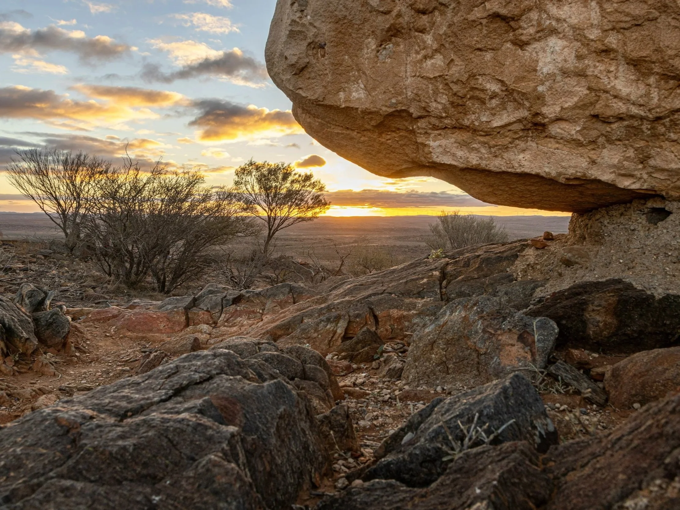
Weathered red and ochre rock outcrops glow at sunset across the Pilbara Craton in northwestern Australia. This timeworn terrain within the Hamersley Range exposes Archean continental crust between 3.5 and 3.8 billion years old, including iron-rich formations that record early volcanic activity and the gradual oxygenation of Earth’s ancient oceans.
If Barberton is a manuscript of early Earth, the Pilbara Craton in northwestern Australia is a vast epic, written in iron and red stone. Here, the land itself is a relic of the Archean Eon, preserving some of the planet’s oldest continental crust, aged between 3.8 and 3.55 billion years (Hickman, 2012; NASA Earth Observatory, 2022). The Hamersley Range, within this craton, adds dramatic relief: gorges, cliffs, and valleys carved into banded iron formations that shimmer like rust-colored strata under the Australian sun (Pare, 2024).
Geological significance
Pilbara is a craton, a stable core of continental crust that has survived billions of years of tectonic upheaval. It bears evidence of ancient volcanic cycles, granitic intrusions, and sedimentary sequences that chronicle the evolution of early Earth. Between 3.53 and 3.22 billion years ago, mantle plumes created volcanic supergroups, while later tectonic movements consolidated the craton into a thick, enduring continental mass (Hickman, 2012).
But the rocks are more than inert stone. Embedded within shallow marine sediments of Fortescue and Hamersley are stromatolites—layered microbial mats that provide a rare glimpse into some of Earth’s earliest life, dating back 3.45 billion years (NASA Earth Observatory, 2022). Banded iron formations, meanwhile, tell a story of rising oxygen levels long before complex life emerged, recording the delicate chemical balancing act of early oceans (Pare, 2024).
What visitors experience
For travelers, Pilbara is both remote and immersive. Karijini National Park offers gorges carved into iron-rich sandstone, waterfalls cascading into clear pools, and vast, silent expanses of desert-like terrain punctuated by vivid red escarpments. The scale is overwhelming: the silence, the heat, the expanse evoke a sense of walking across the planet’s childhood. Trails wind past evidence of billions of years of geological history, every rock layer a frozen chapter, every outcrop a memoir of Earth’s early rhythms.
The Hamersley Range is not just a geological wonder; it is a sensory experience. The mineral hues of ochre, gold, and deep rust under the intense sunlight, the wind carving fine patterns across exposed rocks, the distant echo of waterfalls—all create a landscape that feels both alien and ancient, a time capsule open to anyone who ventures here (Pare, 2024; Hickman, 2012).
Accessibility
Pilbara is remote, demanding careful planning. Flights connect to nearby towns, and visitors must navigate rugged roads or join guided tours to reach the park’s most spectacular features. Yet, with preparation, these landscapes are fully visitable. They invite travelers to step into Earth’s ancient heartland, to touch crust that has remained largely unaltered for more than three billion years, and to encounter a planetary history that dwarfs human chronology.
Australia’s Pilbara Craton is a living archive, where red gorges and iron-rich plateaus expose the endurance of continental crust. Here, the Earth’s long and slow processes become legible, a vivid contrast to the frenetic pace of daily life. Standing among these rocks, one cannot help but feel the weight of time, the continuity of planetary processes, and the fleeting nature of human existence (NASA Earth Observatory, 2022; Pare, 2024).
4️⃣ Isua Greenstone Belt — Earth’s first fabrics of rock
Far to the north, in western Greenland, the Isua Greenstone Belt whispers of a planet still young, just emerging from its molten infancy. These rocks, dated between 3.7 and 3.8 billion years ago, are fragments of some of the Earth’s earliest crust, preserved in a landscape shaped by unimaginable spans of time (Rollinson, 2002). Here, mountains are not measured only in meters, but in eons.
Geological significance
Isua is not a monolith but a mosaic. Its terrain is divided into five structural domains, each with its own history of metamorphism and deformation. Granate porphyroblasts—garnet crystals formed under high pressures—record multiple episodes of growth, revealing the dynamic conditions of early Earth. In some areas, rocks experienced temperatures above 610 °C, only to survive, transformed but unbroken, for nearly four billion years (Rollinson, 2002).
What it feels like to visit
Isua is not easily accessed. Rugged terrain and Arctic conditions mean that only determined researchers—and occasionally adventurous travelers—can tread its surfaces. Yet, for those who do, the experience is profound. The rock feels both solid and ancient underfoot, a tangible link to a time when Earth’s surface was just beginning to resemble the continents we know today. The silence of Greenland amplifies the impression of deep time, each step across the belt echoing billions of years of slow metamorphic processes.
Accessibility
Visits to Isua require careful planning, often through scientific expeditions. The landscape is remote and challenging, but entirely real and touchable for those willing to endure its isolation. Unlike more touristic destinations, Isua offers a sense of being on the very frontier of geological history.
Standing on these rocks is to stand at the very brink of life and continents, a humbling reminder of the slow, patient forces that shaped the world we inhabit today.
5️⃣Acasta Gneiss Complex — the first crust of a young planet
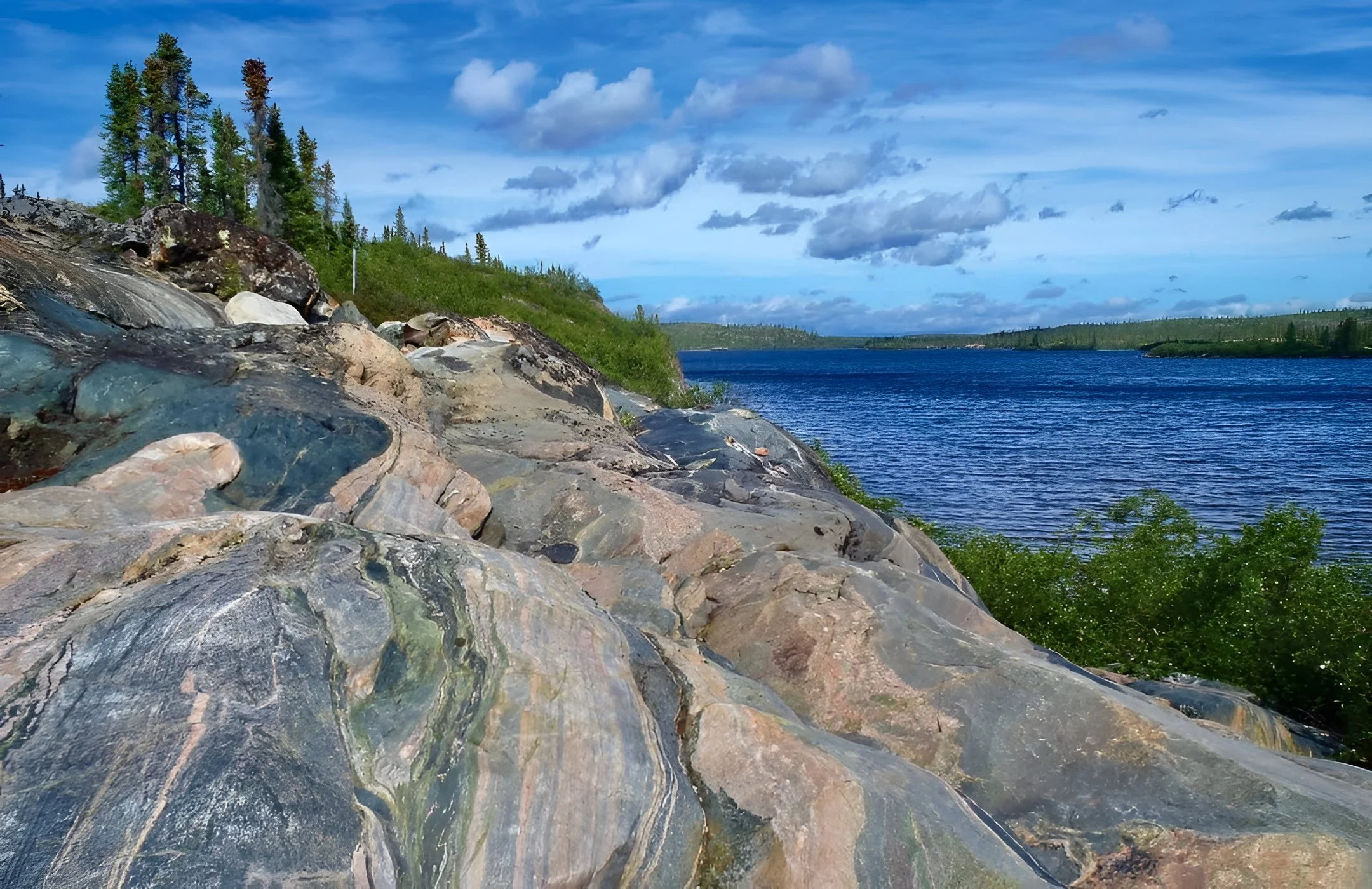
Exposed banded gneiss along a remote lake shoreline in Canada’s Northwest Territories, part of the Acasta Gneiss Complex, the oldest confirmed rocks on Earth, dated up to 4.03 billion years. These tonalite–trondhjemite–granodiorite formations preserve fragments of Earth’s earliest continental crust within the ancient Slave Craton, offering a rare opportunity to walk on Hadean-age foundations still visible at the surface. Credits for the picture: scripps_ocean.
In the far northwest of Canada, where the land stretches into the quiet vastness of the Slave Craton, the Acasta Gneiss Complex waits like a memory frozen in stone. Here, the oldest confirmed rocks on Earth lie exposed, aged between 3.92 and 4.03 billion years, whispering tales from just hundreds of millions of years after the planet’s birth (Orwig, 2014; Open Geology, n.d.; Jeffries, 2025).
Why it’s unique
The Acasta Gneiss is extraordinary not only for its age but for its story. These rocks, mainly tonalite–trondhjemite–granodiorite gneisses, preserve a record of the very earliest continental crust. Isotopic analyses, especially of zircon crystals, reveal that their source material formed as early as 4.3 billion years ago, during the Hadean — when Earth was still a molten, churning sphere (Orwig, 2014; Jeffries, 2025). These fragments survived billions of years of tectonic upheaval, glaciation, and erosion, offering the rarest glimpse of the planet’s infancy.
Acasta is more than a formation; it is the primordial architecture of the continents, the skeletal framework on which all later geology was built.
Can you visit?
Visiting Acasta is not tourism in the conventional sense. The site is remote, deep in Canadian wilderness, accessible only by expedition logistics involving small aircraft, boats, or long treks. Yet for those who make the journey, the experience is profound. Standing on these rocks is to touch Earth’s first solid surface, to walk in a landscape that has endured longer than life itself. The isolation amplifies the feeling of temporal vertigo: one foot on a planet only half a billion years old, the other still grounded in the present.
Acasta is the ultimate pilgrimage into deep time. It reminds us that Earth’s history is not merely written in books, but in the stubborn persistence of rock. For anyone willing to venture there, it is an encounter with the very beginning.
How these ancient landscapes survived billions of years
It is almost miraculous that any of Earth’s earliest crust is still visible. Most original rocks were recycled or eroded long ago, yet places like the Guiana Highlands, Barberton, Pilbara, Isua, and Acasta endure. Their secret is cratons, thick, buoyant cores of continental crust with deep roots that anchor them and shield them from tectonic upheaval.
These landscapes are Earth’s bones: volcanic sequences nearly 3.5 billion years old, stromatolite-rich Pilbara, and Hadean echoes in Acasta. Their survival is a combination of thickness, rigidity, and isolation through eons of geological change.
Visiting them is humbling. Standing on rocks older than life itself stretches perspective, teaching patience, resilience, and awe at the slow, enduring rhythms of the planet. Each fold, each outcrop, each mineral layer is a reminder that while human lives are fleeting, the Earth endures, quietly shaping the world beneath our feet.
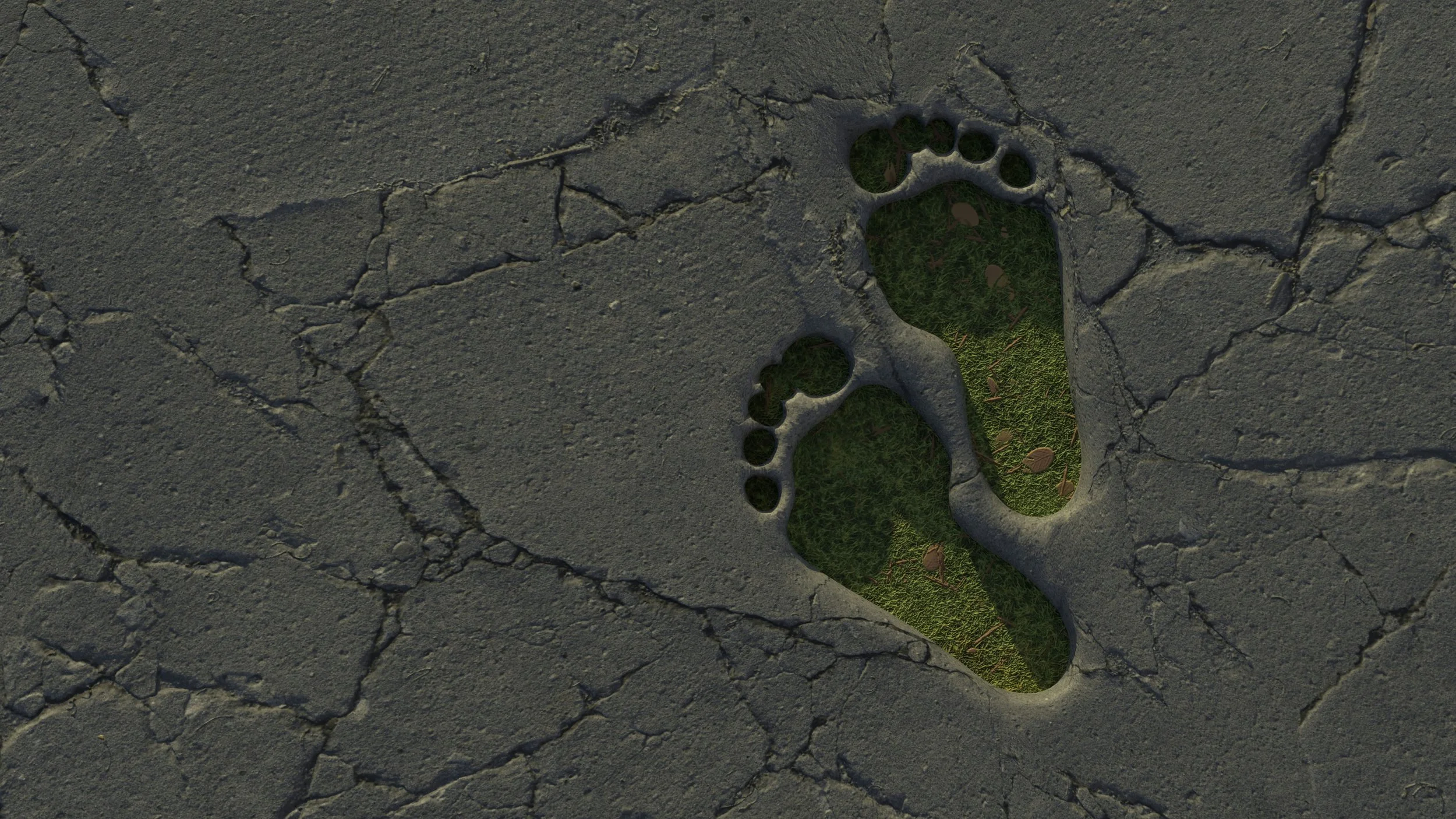
A human footprint impression carved into cracked stone, revealing green grass beneath, a symbolic image of humanity’s brief presence atop Earth’s oldest continental crust. The photo visually represents how ancient cratons like the Acasta Gneiss Complex, Pilbara Craton, and Barberton Greenstone Belt have survived billions of years of tectonic upheaval, erosion, and planetary transformation while human history occupies only a thin surface layer.
References
Asrat, A. (n. d.). Archean Barberton Greenstone Belt. International Commission on Geoheritage. https://iugs-geoheritage.org/subcomission-on-sites/
Nutman, A., Bennett, V., Friend, C., & Van Kranendonk, M. (2019). The Eoarchean legacy of Isua (Greenland) worth preserving for future generations. Earth-Science Reviews, Volume 198, 102923, ISSN 0012-8252. DOI: https://doi.org/10.1016/j.earscirev.2019.102923.
Britannica Editors. "Guiana Highlands". Encyclopedia Britannica, 1 Jul. 2024, https://www.britannica.com/place/Guiana-Highlands. Accessed 24 February 2026.
Hickman, A. H. (2012). Review of the Pilbara Craton and Fortescue Basin, Western Australia: Crustal evolution providing environments for early life. Island Arc, Vol. 21, Issue 1. Pages 1-31. DOI: https://doi.org/10.1111/j.1440-1738.2011.00783.x
Jeffries, E. (2025). The Secrets of How Life Began May Be Hidden Inside the World’s Oldest Rocks. Smithsonian Magazine. https://www.smithsonianmag.com/smithsonian-institution/the-secrets-of-how-life-began-may-be-hidden-inside-the-worlds-oldest-rocks-180986638/
LAC (Latin America & Caribbean Geographic). (2025). Guiana Highlands: Islands in the Sky, Emerald Heart of a Continent. https://lacgeo.com/guiana-highlands
NASA Earth Observatory. (2021). Venezuela’s Flat-Topped Mountains. https://science.nasa.gov/earth/earth-observatory/venezuelas-flat-topped-mountains-148520/
NASA Earth Observatory. (2008). Barberton Mountains, South Africa. https://science.nasa.gov/earth/earth-observatory/barberton-mountains-south-africa-35970/
NASA Earth Observatory. (2022). Assembling Australia. https://science.nasa.gov/earth/earth-observatory/assembling-australia-149654/
Orwig, J. (2014), Formation process of Archean rocks in the Acasta Gneiss Complex, Eos, 95, doi:10.1029/2014EO021275. Published on 31 December 2014.
Open Geology. (n. d.). Earth's Oldest Rocks – Historical Geology. https://opengeology.org/historicalgeology/case-studies/earths-oldest-rocks/
Pare, S. (2024). World's largest iron ore deposits formed over 1 billion years ago in supercontinent breakup. LiveScience. https://www.livescience.com/planet-earth/geology/world-s-largest-iron-ore-deposits-formed-over-1-billion-years-ago-in-supercontinent-breakup
Rollinson, H. (2022). The metamorphic history of the Isua Greenstone Belt, West Greenland. Geological Society, London, Special Publications. Volume 199, Pages 329 - 350. DOI: https://doi.org/10.1144/GSL.SP.2002.199.01.16
The Amazon Conservation Team. (n. d.). The Guiana Shield: One of the Last Wild Places on Earth. https://amazonteam.org/maps/guiana-shield/